Interfacing with PyVista and VTK 3D plotting (version 0.4.0+)
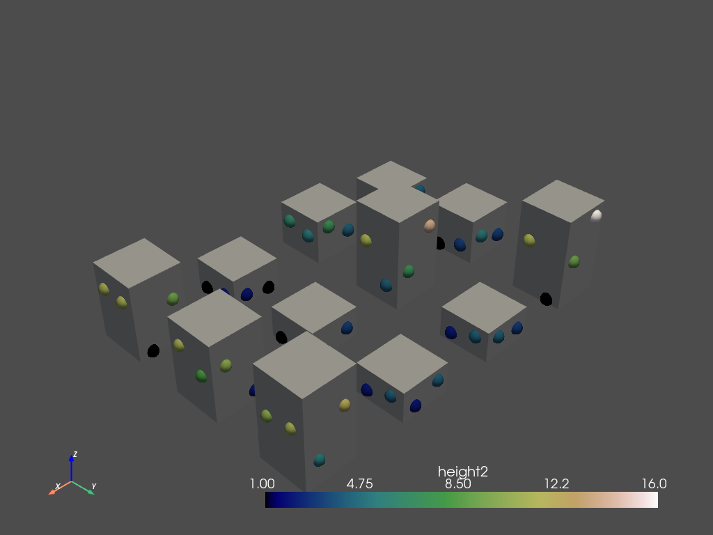
Simple 3D display (version 0.4.0+)
As written on docs.pyvista.org, PyVista is "a
high-level API to the [3D] Visualization Toolkit (VTK)". Provided you have installed it correctly (which conda does very well via a conda install pyvista!), the following instructions allow you to switch from the traditional 2D geomatics environment to a 3D environment:
from numpy.random import randint
from t4gpd.commons.GeomLib import GeomLib
from t4gpd.demos.GeoDataFrameDemos import GeoDataFrameDemos
from t4gpd.morph.geoProcesses.FootprintExtruder import FootprintExtruder
from t4gpd.morph.geoProcesses.STGeoProcess import STGeoProcess
from t4gpd.morph.STPointsDensifier2 import STPointsDensifier2
from t4gpd.pyvista.ToUnstructuredGrid import ToUnstructuredGrid

buildings = GeoDataFrameDemos.regularGridOfPlots(3, 4, dw=5.0)
buildings['n_floors'] = randint(2, 7, size=len(buildings))
buildings['height'] = 3.0 * buildings.n_floors

sensors = STPointsDensifier2(buildings, curvAbsc=[0.25, 0.75], pathidFieldname=None).run()
sensors['height2'] = sensors.height.apply(lambda h: randint(1.0, h - 1.0))
sensors['__TMP__'] = list(zip(sensors.geometry, sensors.height2))
sensors.geometry = sensors.__TMP__.apply(lambda t: GeomLib.forceZCoordinateToZ0(t[0], z0=t[1]))
sensors.drop(columns=['__TMP__'], inplace=True)

op = FootprintExtruder(buildings, 'height', forceZCoordToZero=True)
buildingsIn3d = STGeoProcess(op, buildings).run()

scene1 = ToUnstructuredGrid([buildingsIn3d, sensors], 'height2').run()
scene1.plot(scalars='height2', cmap='gist_earth', show_edges=False,
    show_scalar_bar=True, point_size=20.0, render_points_as_spheres=True,
    screenshot='pyvista_1.png')
As you may notice, the t4gpd.pyvista.ToUnstructuredGrid class provides a way to wrap a list of GeoDataFrames before passing them to PyVista.
3D ray casting (version 0.4.0+)
The coupling to the PyVista.org library allows a robust and powerful ray casting in a 3D urban model (a small test allows me to cast two million rays in 67 seconds).
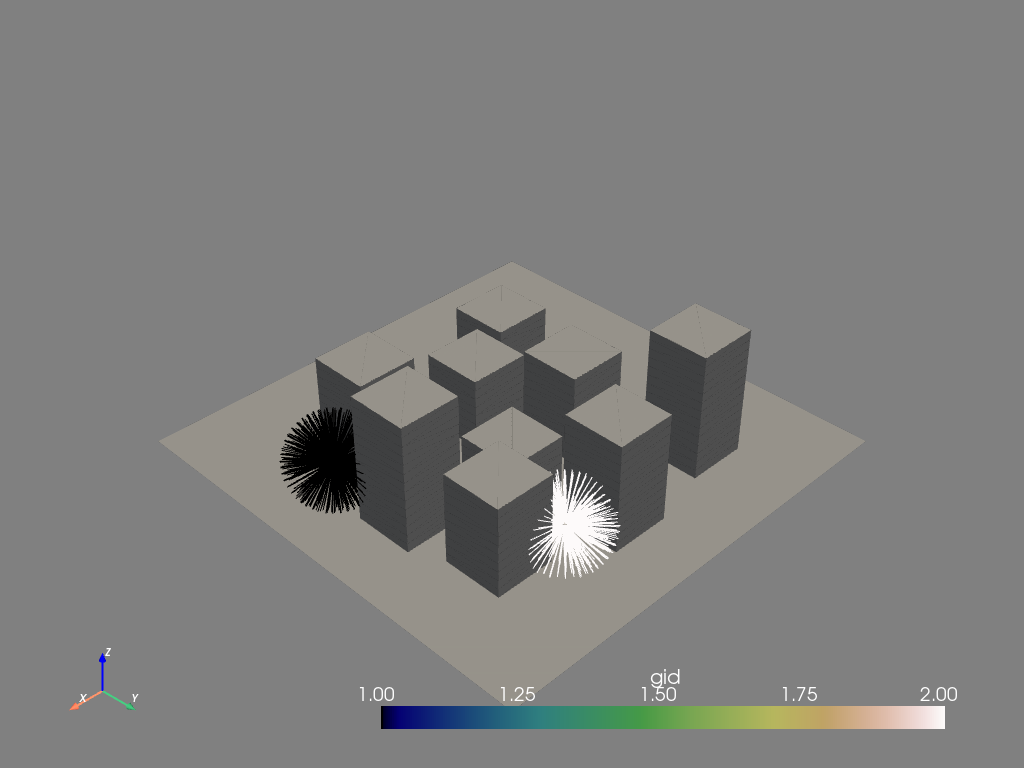
Panoptic ray casting in 3D (version 0.4.0+)
To be able to cast these rays, let's start by building a (small) 3D model with two "sensors":
from geopandas import GeoDataFrame
from shapely.geometry import Point
from t4gpd.demos.GeoDataFrameDemos5 import GeoDataFrameDemos5

buildings = GeoDataFrameDemos5.cirSceneMasque1Corr()
sensors = GeoDataFrame(data=[
    { 'gid': 1, 'geometry': Point(130, 60, 15) },
    { 'gid': 2, 'geometry': Point(100, 120, 10) },
])
The model being built, let's proceed to the (panoptic) ray casting:
from t4gpd.morph.geoProcesses.STGeoProcess import STGeoProcess
from t4gpd.pyvista.ToUnstructuredGrid import ToUnstructuredGrid
from t4gpd.pyvista.geoProcesses.PanopticRayCasting3D import PanopticRayCasting3D

nrays = 512
op = PanopticRayCasting3D([buildings], maskPkFieldname=None, nrays=nrays,
    method='geodeciel', maxRayLen=15, encode=True)
rays = STGeoProcess(op, sensors).execute()
In the above code snippet, we arbitrarily decided to:
-
limit the length of the rays to 15 m (parameter maxRayLen),
-
cast the rays using the 'geodeciel' strategy (the parameter method takes its value among 'icosahedron', 'pyvista', 'MonteCarlo', etc.).
All that remains is to execute the following code snippet to produce a 3D representation:
from pyvista import global_theme
from t4gpd.pyvista.ToUnstructuredGrid import ToUnstructuredGrid

global_theme.background = 'grey'
global_theme.axes.show = True

scene = ToUnstructuredGrid([buildings, sensors, rays], 'gid').run()
scene.plot(show_edges=True, point_size=10.0,
    render_points_as_spheres=True, scalars='gid',
    cmap='gist_earth', screenshot='img/pyvista_panoptic_raycasting.png')
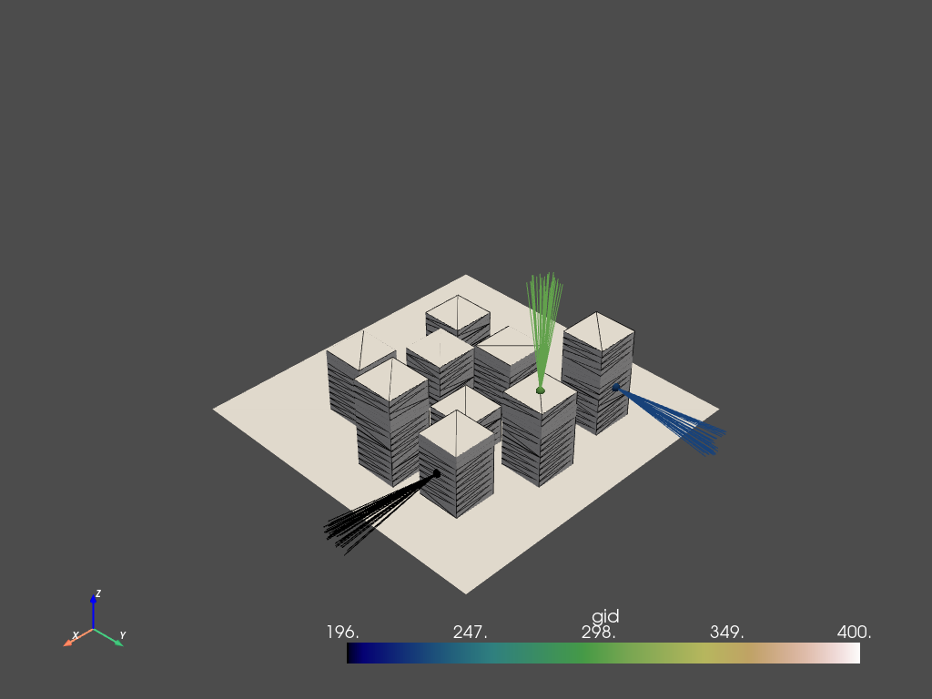
Oriented ray casting in 3D (version 0.4.0+)
To be able to cast these rays, let's start by building a (small) 3D model and anchoring some sensors in its facades:
from t4gpd.commons.GeomLib3D import GeomLib3D
from t4gpd.demos.GeoDataFrameDemos5 import GeoDataFrameDemos5
from t4gpd.morph.geoProcesses.STGeoProcess import STGeoProcess
from t4gpd.pyvista.geoProcesses.MoveSensorsAwayFromSurface import MoveSensorsAwayFromSurface

# Let's generate a set of building footprints
buildings = GeoDataFrameDemos5.cirSceneMasque1Corr()
buildings['normal_vec'] = buildings.geometry.apply(lambda g: GeomLib3D.getFaceNormalVector(g))
buildings.reset_index(inplace=True)
buildings.rename(columns={'index': 'gid'}, inplace=True)

# Let's anchor the sensors on the facades (at a distance of 0.1 m from the facades)
sensors = buildings.copy(deep=True)
#~ Keep only a few sensors
sensors = sensors[ sensors.gid.isin([196, 226, 300]) ]
sensors['main_dir'] = sensors.normal_vec
sensors.reset_index(drop=True, inplace=True)

sensors.geometry = sensors.geometry.apply(lambda g: GeomLib3D.centroid(g))
op = MoveSensorsAwayFromSurface(sensors, 'normal_vec', dist=1e-1)
sensors = STGeoProcess(op, sensors).run()
The model being built, let's proceed to the (oriented) ray casting:
from t4gpd.pyvista.geoProcesses.OrientedRayCasting3D import OrientedRayCasting3D

nrays = 32
op = OrientedRayCasting3D([buildings], maskPkFieldname=None,
    viewpoints=sensors, mainDirectionFieldname='main_dir',
    openness=8, nrays=nrays, maxRayLen=50, encode=False)
rays = STGeoProcess(op, sensors).execute()
In the above code snippet, we arbitrarily decided to:
-
limit the length of the 32 rays (parameter nrays) to 50 m (parameter maxRayLen),
-
cast the rays around a given direction (provided by parameter mainDirectionFieldname) with an openness equal to 8° (parameter openness),
-
cast the rays using a random strategy (in a Monte Carlo approach, random sampling of the surrounding space).
All that remains is to execute the following code snippet to produce a 3D representation:
from pyvista import Plotter
from t4gpd.pyvista.ToUnstructuredGrid import ToUnstructuredGrid

buildings.gid = 400

scene = ToUnstructuredGrid([buildings, sensors, rays], 'gid').run()

scene.plot(show_edges=True, point_size=10.0,
    render_points_as_spheres=True, scalars='gid',
    cmap='gist_earth', screenshot='img/pyvista_oriented_raycasting.png')
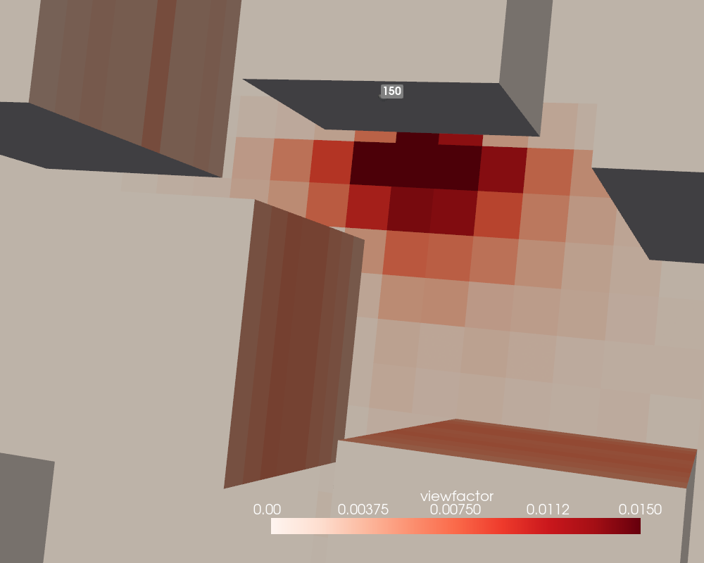
Estimation of view factors using ray casting (version 0.4.0+)
The aim here is to estimate and represent the view factors associated with a sensor placed on the front of a building. Let's start by loading the urban model. We then separate the buildings from the ground surface by a simple filter on the value of the z component of the centroid. This allows us to grid the ground surface before regrouping the whole model by concatenation.
from pandas import concat, merge
from t4gpd.commons.GeomLib import GeomLib
from t4gpd.commons.GeomLib3D import GeomLib3D
from t4gpd.demos.GeoDataFrameDemos5 import GeoDataFrameDemos5
from t4gpd.morph.STGrid import STGrid
from t4gpd.morph.geoProcesses.STGeoProcess import STGeoProcess
from t4gpd.pyvista.geoProcesses.MoveSensorsAwayFromSurface import MoveSensorsAwayFromSurface

# Let's load a pre-registered 3D dataset
buildings = GeoDataFrameDemos5.cirSceneMasque1Corr()
buildings['normal_vec'] = buildings.geometry.apply(lambda g: GeomLib3D.getFaceNormalVector(g))
buildings['height'] = buildings.geometry.apply(lambda g: GeomLib3D.centroid(g).z)

# Let's extract only the building surfaces
buildings2 = buildings.loc[ buildings[buildings['height'] > 0].index ]
buildings2.reset_index(inplace=True, drop=True)

# Let's extract the ground surface and grid it
ground = buildings.loc[ buildings[buildings['height'] == 0].index ]
ground.reset_index(inplace=True, drop=True)
groundGrid = STGrid(ground, dx=4, dy=None, indoor=True, intoPoint=False).run()
groundGrid.geometry = groundGrid.geometry.apply(
    lambda g: GeomLib.forceZCoordinateToZ0(g, z0=0.0))
groundGrid['normal_vec'] = groundGrid.gid.apply(lambda _: [0,0,1])
groundGrid['height'] = 0

# Let's group these two sets of faces by concatenation
masks = concat([buildings2, groundGrid[['geometry', 'normal_vec', 'height']]])
masks.reset_index(inplace=True, drop=True)

# Be careful, the pk attribute must be unique (it is a primary key to use
# the Relational Databases terminology)
masks['pk'] = masks.index

# Let's deploy the sensors
sensors = masks.copy(deep=True)
sensors.geometry = sensors.geometry.apply(lambda g: GeomLib3D.centroid(g))
op = MoveSensorsAwayFromSurface(sensors, normalFieldname='normal_vec', dist=1e-6)
sensors = STGeoProcess(op, sensors).execute()

# Let's select the only sensor of number 150
sensors = sensors.loc[ sensors[sensors.pk == 150].index ]
The model being built, let's proceed to the ray casting:
from t4gpd.pyvista.commons.RayCasting3DLib import RayCasting3DLib
from t4gpd.pyvista.geoProcesses.RayCasting3D import RayCasting3D
from t4gpd.pyvista.STRaysToViewFactors import STRaysToViewFactors

# Let's prepare a set of 10,000 uniformly distributed rays
shootingDirs = RayCasting3DLib.preparePanopticRays(nrays=10000)

# Let's cast the already prepared rays
op = RayCasting3D([masks], shootingDirs, viewpoints=sensors,
                  normalFieldname='normal_vec', pkFieldname='pk')
rays = STGeoProcess(op, sensors).execute()

# Let's convert the DataFrame of rays into a sparse matrix of view factors
vfSparseMatrix = STRaysToViewFactors(rays, 'pk', 'hitGids').run()

# Let's assign these view factors to each face of the model by means of an attribute join
masks2 = merge(masks, vfSparseMatrix[['dst', 'viewfactor']], how='left',
    left_on='pk', right_on='dst')
masks2.viewfactor = masks2.viewfactor.fillna(value=0)
It remains then to display the results:
from pyvista import global_theme, Plotter, Sphere
from t4gpd.pyvista.ToUnstructuredGrid import ToUnstructuredGrid

# The positions stored in the centroids list will allow us to display the
# number 150 sensor label in the right place
centroids = sensors.geometry.apply(lambda g: g.coords[0]).to_list()
scene = ToUnstructuredGrid([masks2, sensors], 'viewfactor').run()

global_theme.background = 'grey'
global_theme.axes.show = True

plotter = Plotter(window_size=(1000, 800))
# To improve the readability of the rendering we limit the color range using 'clim'
plotter.add_mesh(scene, scalars='viewfactor', cmap='reds', show_edges=False,
    show_scalar_bar=True, point_size=15.0, clim=[0,0.015],
    render_points_as_spheres=True)
plotter.add_point_labels(centroids, sensors.pk.to_list(), font_size=16, point_size=1)
plotter.camera_position = 'xy'
plotter.show()
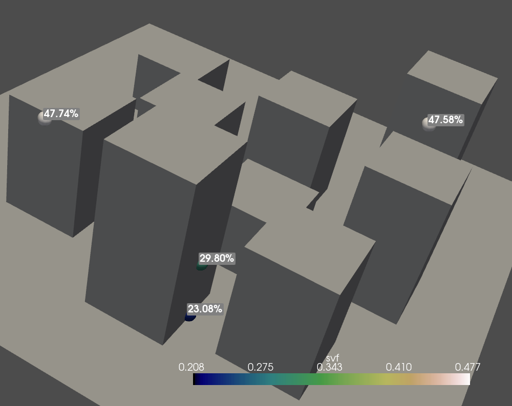
Estimation of Sky View Factors using ray casting (version 0.4.0+)
Warning: in version 0.4.1 of the package, this feature does not work properly on Windows where the recovery of face identifiers when raycasting via PyVista is not properly ensured. A new version - optimized and debugged - is currently under development.
The aim here is to estimate and represent the Sky View Factors associated with sensors placed on the front of buildings. Let's start by loading the urban model and by locating the sensors on the building facades.
from t4gpd.commons.GeomLib3D import GeomLib3D
from t4gpd.demos.GeoDataFrameDemos5 import GeoDataFrameDemos5
from t4gpd.morph.geoProcesses.STGeoProcess import STGeoProcess
from t4gpd.pyvista.geoProcesses.MoveSensorsAwayFromSurface import MoveSensorsAwayFromSurface

buildings = GeoDataFrameDemos5.cirSceneMasque1Corr()
buildings['normal_vec'] = buildings.geometry.apply(lambda g: GeomLib3D.getFaceNormalVector(g))
buildings.reset_index(inplace=True)
buildings.rename(columns={'index': 'gid'}, inplace=True)

sensors = buildings.copy(deep=True)
# WE KEEP ONLY A FEW SENSORS
sensors = sensors[ sensors.index % 90 == 0 ]
sensors['main_dir'] = sensors.normal_vec
sensors.reset_index(drop=True, inplace=True)

sensors.geometry = sensors.geometry.apply(lambda g: GeomLib3D.centroid(g))
op = MoveSensorsAwayFromSurface(sensors, 'normal_vec', dist=0.1)
sensors = STGeoProcess(op, sensors).run()
The model being built, let's proceed to the SVF estimation:
from t4gpd.pyvista.geoProcesses.SVF3D import SVF3D

op = SVF3D([buildings], nrays=5000, method='MonteCarlo')
result = STGeoProcess(op, sensors).execute()
It remains then to display the results:
from pyvista import Plotter
from t4gpd.pyvista.ToUnstructuredGrid import ToUnstructuredGrid

scene = ToUnstructuredGrid([buildings, sensors, result], fieldname='svf').run()

centroids = result.geometry.apply(lambda g: g.coords[0]).to_list()
labels = result.svf.apply(lambda v: f'{100 * v:.2f}%').to_list()

plotter = Plotter(window_size=(1000, 800))
plotter.add_mesh(scene, scalars='svf', cmap='gist_earth',
    show_edges=False, show_scalar_bar=True, point_size=30.0,
    render_points_as_spheres=True, line_width=2.0, color='k')
plotter.add_point_labels(centroids, labels, font_size=20, point_size=1e-3)
plotter.show()